GeoToolkit libraries for Python: Energy‑grade subsurface visualization

SLB‑grade subsurface visualization, now native to Python for AI, analytics, and data science workflows.

Python is the language of choice for data scientists and geoscientists—but until now, it has lacked true subsurface‑gradevisualization. GeoToolkit Python fills that gap, bringing a trusted, domain‑specific visualization engine for the energy industry directly into the Python ecosystem.
Whether you’re exploring seismic data, visualizing model predictions, or building production‑ready subsurface applications, GeoToolkit Python delivers advanced 2D and 3D visualization you can trust.

Who is GeoToolkit Python for?

For data scientists

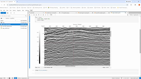
GeoToolkit Python lets data scientists work entirely in Python while gaining access to true subsurface‑grade visualization. Use it in Jupyter...

For Python developers

GeoToolkit Python enables developers to build robust subsurface applications using clean, native Python APIs. Embed advanced 2D and 3D subsur...

For AI agents and automation

GeoToolkit Python provides clear, interpretable subsurface visualization for AI‑driven workflows. Model inputs, features, and predictions can...

Seamless integration with your Python stack

Heading 1

Heading 2

Heading 3

GeoToolkit Python is designed to work effortlessly with the tools you already use:
  • Dataiku and enterprise AI platforms
  • Jupyter & JupyterLab
  • Plotly | Dash
  • NumPy, pandas, and analytics pipelines
Wherever Python runs, GeoToolkit Python provides the visual interface.
Subtitle 1
Subtitle 2
Subtitle 3
Anchor: Video

See GeoToolkit Python in action

Subsurface insight starts with visualization you can trust. Watch the GeoToolkit Python demo
Anchor: Case-studies

Why GeoToolkit Python?

Whether you're building AI workflows, developing internal applications, or exploring complex subsurface datasets, GeoToolkit Python delivers a unified, energy‑grade visualization foundation

Built specifically for energy workflows

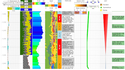
GeoToolkit Python is designed from the ground up for subsurface and energy use cases, supporting the visualization patterns, data types, and dom...

Trusted, enterprise‑grade visualization engine

GeoToolkit Python is powered by a proven visualization engine used in demanding subsurface applications, delivering the reliability, performance...

Native Python experience for data science and AI

GeoToolkit Python works seamlessly inside Python environments, enabling data scientists and AI teams to visualize subsurface data and model outp...

Explore all features free for 30 days

Start your free 30‑day trial

Frequently Asked Questions

Find answers to common questions about GeoToolkit libraries for Python

What features are included in the free trial?

The trial includes full access to subsurface‑grade 2D and 3D visualization, interactive components, and Python integrations so you can evaluate GeoToolkit Python in real workflows.

Which Python environments are supported?

GeoToolkit Python works in common development environments including Jupyter, JupyterLab, VS Code, PyCharm, and web frameworks such as Dash.

Is GeoToolkit Python suitable for production use?

Yes. GeoToolkit Python is built on a trusted, enterprise‑grade visualization engine designed for production‑scale subsurface applications.

What happens when the trial ends?

At the end of the trial, you can choose a subscription option or contact the team to discuss enterprise licensing. Your workflows and code remain fully portable.

Where can I find more information about GeoToolkit?

You can explore additional resources on the